

GPS vs DGPS – What Is the Difference?
Captain's Corner Magazine · 15 August 2026
How differential corrections improve satellite positioning, and why greater accuracy matters in marine navigation.
Modern navigation depends heavily on satellite positioning, and two terms that are often encountered in marine navigation are GPS and DGPS. Although both systems use the same GPS satellites, DGPS improves the accuracy of the position by introducing an additional correction system on the ground.
What Is GPS?
GPS – Global Positioning System – is a satellite-based navigation system that allows a receiver to determine its position, speed and precise time almost anywhere on Earth. A GPS receiver calculates its position by receiving radio signals from several satellites orbiting the Earth. Each satellite continuously transmits information containing its precise orbital position and an accurate time signal. By comparing the arrival times of signals from several satellites, the receiver calculates its distance from each satellite and determines its position through a process known as trilateration. For a reliable three-dimensional position, the receiver normally needs signals from at least four satellites. Standard standalone GPS typically provides an accuracy of approximately 5–15 metres, although modern receivers can often perform better when satellite geometry and atmospheric conditions are favourable. The main advantage of GPS is that it requires no local ground infrastructure. A GPS receiver only needs a clear enough view of the sky to receive the satellite signals.
What Is DGPS?
DGPS – Differential Global Positioning System – uses the same GPS satellite signals but improves their accuracy by adding information from a fixed ground-based reference station. The important difference is that the exact geographical position of the DGPS reference station is already known.
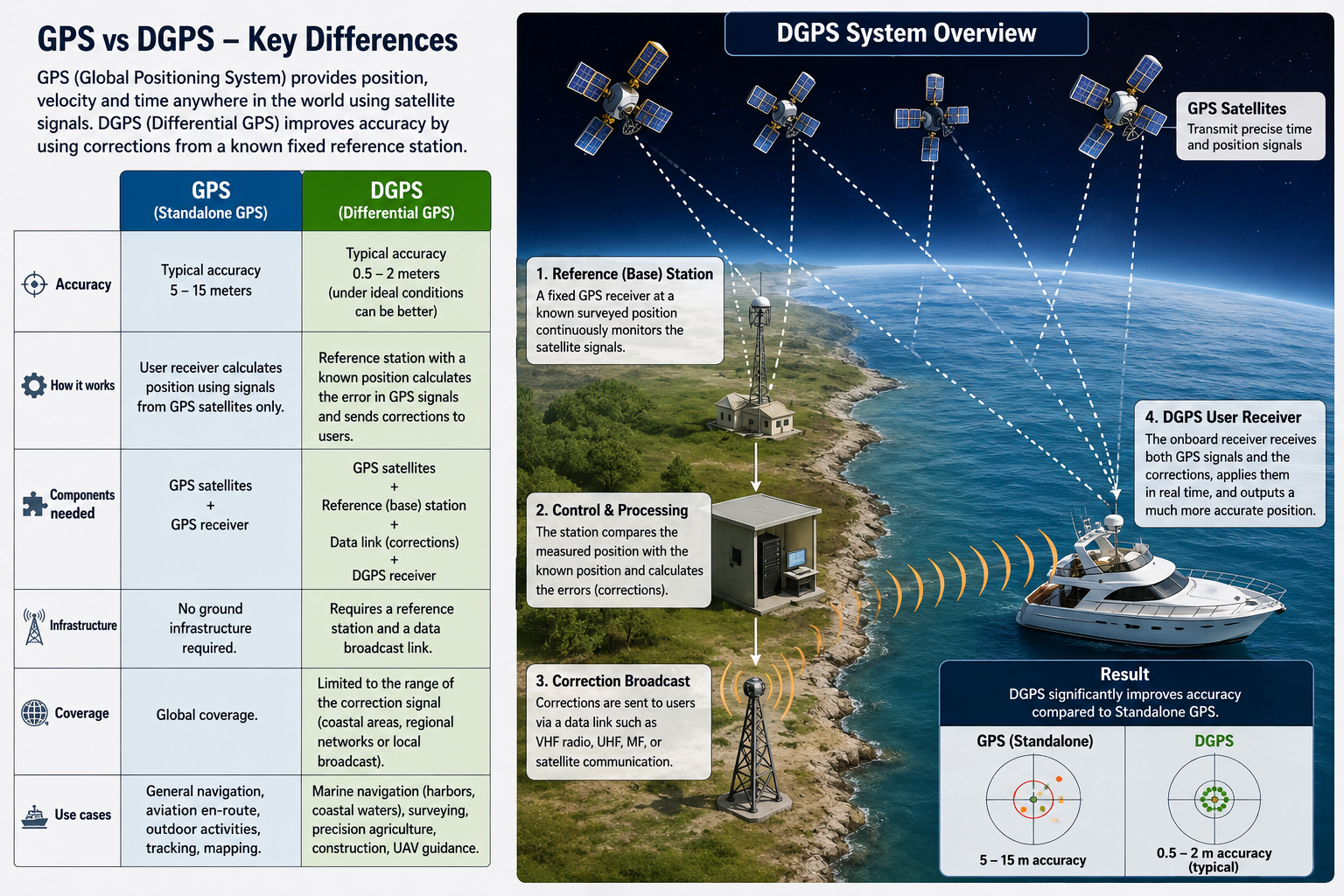
The reference station receives the same satellite signals as other GPS receivers in the surrounding area. It compares the position calculated from the GPS satellites with its precisely surveyed, known position. Any difference between these two positions represents an error in the GPS measurement. The station then calculates corrections and broadcasts them to nearby DGPS users. An onboard DGPS receiver receives both the normal GPS satellite signals and the correction information transmitted by the reference station.
The receiver applies these corrections in real time, producing a considerably more accurate position. Typical DGPS accuracy is approximately 0.5–2 metres, and under favourable conditions it can be even better.
How DGPS Works Step by Step
The DGPS process can be divided into four basic stages.
1. GPS satellites transmit navigation signals. Several GPS satellites transmit precise timing and orbital information toward Earth. Both the reference station and the vessel receive these signals.
2. The reference station calculates the GPS error. Because the exact position of the reference station is already known, it can compare its GPS-calculated position with its true surveyed position. For example, if the GPS receiver says the station is five metres east of where it actually is, the system recognizes approximately five metres of positioning error.
3. Corrections are transmitted. The reference station calculates correction data and broadcasts it to users in the surrounding area. Depending on the DGPS system, corrections may be transmitted using radio frequencies such as MF, VHF or UHF, or through other communication systems.
4. The vessel applies the correction. The vessel's DGPS receiver receives both the satellite signals and the correction message. The correction is applied to the GPS calculation, significantly improving the accuracy of the vessel's displayed position.
GPS vs DGPS
The main difference between the two systems is therefore not the satellites themselves. Both systems rely on GPS satellites. The difference is that standalone GPS determines the vessel's position directly from the satellite signals, while DGPS adds a correction calculated by a reference station whose position is already precisely known. In simplified terms:
GPS: GPS satellites → GPS receiver → calculated position.
DGPS: GPS satellites → reference station → error calculation → correction broadcast → vessel's DGPS receiver → corrected position.
Accuracy
A typical comparison is: standalone GPS, approximately 5–15 metres; DGPS, approximately 0.5–2 metres. Actual accuracy varies depending on satellite geometry, atmospheric conditions, interference, receiver quality and the correction service being used. The improvement provided by DGPS can be particularly important when operating close to navigational hazards. A position error of several metres may have little importance when crossing an ocean, but it can become significant when navigating through a narrow channel, approaching a harbour entrance or manoeuvring close to rocks, shoals or other vessels.
Why GPS Positions Contain Errors
Several factors can affect GPS accuracy. One of the most important is the Earth's atmosphere. Satellite radio signals must travel through the ionosphere and troposphere before reaching the receiver, and these layers can slightly delay the signal.
Satellite orbital and clock errors can also contribute to positioning errors. Another important factor is satellite geometry. If the satellites visible to the receiver are widely distributed across the sky, the calculated position is generally more accurate. If they are clustered close together, the geometry becomes less favourable and the possible error increases. Signals can also reflect from buildings, cliffs, cranes or other large structures before reaching the antenna. This phenomenon, known as multipath, can further reduce accuracy. Because a DGPS reference station and a nearby vessel experience many of the same satellite-related errors, the reference station can estimate those errors and provide useful corrections to the vessel.
DGPS in Marine Navigation
DGPS became particularly important in marine navigation because ships frequently operate in areas where increased positional accuracy is valuable. Typical applications include harbour approaches, coastal navigation, pilotage waters, narrow channels, hydrographic surveying, dredging operations, offshore operations and precision positioning.
For ordinary offshore navigation, standalone satellite positioning is normally more than adequate. However, when precise positioning is required, differential correction can provide a significant advantage.
Does DGPS Replace GPS?
No. DGPS is not a completely separate satellite navigation system. It is essentially an enhancement of GPS. The vessel still determines its fundamental position using GPS satellites. DGPS simply provides additional information that allows the receiver to correct some of the errors contained in the normal GPS solution. Without the underlying GPS signals, DGPS cannot determine the vessel's position.
The Simple Explanation
The easiest way to understand the difference is to imagine two GPS receivers. One receiver is installed on your vessel. The other is installed at a surveyed position on shore where its exact coordinates are already known. If the shore receiver calculates a position that is slightly different from its known true position, it knows that there is currently an error in the GPS signal. It calculates that error and sends the correction to your vessel. Your vessel then applies the same correction to its own calculated position. That is the basic principle of Differential GPS.
Conclusion
GPS revolutionized navigation by allowing vessels to determine their position anywhere in the world using signals transmitted from satellites. DGPS improves that system by introducing a fixed reference station that measures GPS errors and transmits corrections to nearby users. The essential difference can therefore be summarized very simply: GPS calculates your position from satellites. DGPS calculates your position from satellites and then corrects it using information from a known reference station. For a navigator, the practical result is greater positional accuracy and additional confidence when operating in confined or safety-critical waters.
More in Knowledge
 Knowledge
Life-Saving Equipment Offshore: PLBs, EPIRBs, SARTs and Satellite Communicators
Four technologies that decide how quickly rescuers find you — PLBs, EPIRBs, SARTs and satellite communicators — and why a well-equipped offshore yacht carries several of them.
Captain's Corner Magazine · 17 October 2026
 Knowledge
Chart Inaccuracies – Understanding the Limits of Paper Charts and ENCs
Your GNSS position may be accurate to a few metres — but the shoal on the chart may come from a survey a century old. How survey age, chart compilation and CATZOC shape what you can trust.
Captain's Corner Magazine · 17 October 2026
 Knowledge
From the Ocean to the Human Body: The Growing Impact of Plastic Pollution
A plastic bottle thrown overboard does not disappear — it fragments into microplastics that travel from the sea into soil, crops, drinking water and, ultimately, the human body.
Captain's Corner Magazine · 17 October 2026